Tropical Storm Erin has formed in the eastern Atlantic Ocean and is on track to become the first hurricane of the 2025 Atlantic season, meteorologists said.
The National Hurricane Center in Miami announced on Monday, Aug. 11, that Erin had developed from a tropical wave as it churned west of the Cabo Verde Islands, an archipelago that sits off the western coast of Africa.
As of 11 a.m., the storm was moving west at 20 mph and had sustained winds of 45 mph, the hurricane center said. The storm was located 280 miles west-northwest of the Cabo Verde Islands and over 2,300 miles from the Leeward Islands.
The storm is expected to continue strengthening as it barrels west over the coming days. The hurricane center said several regional models “show Erin becoming a major hurricane,” which is defined as any storm classified as a Category 3 or stronger, meaning it has winds over 110 mph.
Erin was one of three disturbances meteorologists were tracking in the Atlantic – and is the one that poses the biggest threat. It is still early and there are high levels of uncertainty in the storm’s long-term track. Still, experts urge those with interests in the Caribbean and the eastern coast of the U.S. to monitor its development.
Warm Atlantic waters to fuel Erin’s development into a hurricane
As Tropical Storm Erin heads west, it will encounter exceptionally warm waters that could fuel its development into a major hurricane, said AccuWeather’s lead hurricane expert Alex DaSilva.
Water temperatures across much of the Atlantic “are plenty warm to support tropical development and even rapid intensification,” DaSilva said in an online outlook.
He added that there are several factors that could influence where the storm eventually lands, including the strength of a cold front moving off the eastern coast of the U.S.
If the cold front is fast and strong, it could push the storm back out to sea and away from the U.S., DaSilva said. If it’s slow and weak, the storm could push right through it and pose a threat to the Eastern Seaboard. Other factors include wind shear and the position of the “Bermuda High,” an area of high pressure that could steer the hurricane. So far, it’s too early to know where the storm will go.
Storm tracker: Tracking storms in the Atlantic
Spaghetti models for Tropical Storm Erin
This forecast track shows the most likely path of the center of the storm. It does not illustrate the full width of the storm or its impacts, and the center of the storm is likely to travel outside the cone up to 33% of the time.
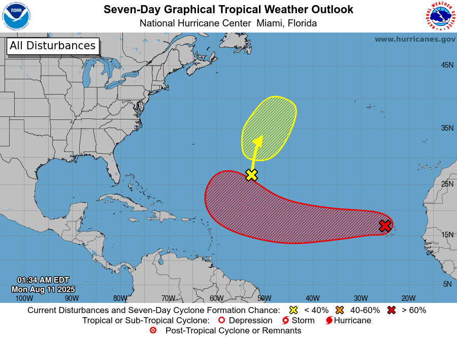
Forecasters track 2 other disturbances in the Atlantic
Apart from Tropical Storm Erin, meteorologists are tracking two systems in the Atlantic Ocean.
In the central Atlantic, a weak trough of low pressure with a low chance of developing is expected to drift northward. The disturbance is “only producing limited shower and thunderstorm activity,” the hurricane center said.
Meanwhile, a few hundreds miles off the coast of Nova Scotia, Canada, a system was tracked moving north over the warm waters of the Gulf Stream. By midweek, forecasters say the system will encounter cooler waters, “ending its chances for further tropical development.”
Both systems have a 10% chance of developing over the next week, according to the National Hurricane Center.
What is happening in the Pacific?
Hurricane Henriette, located north of Hawaii, is forecasted to remain a hurricane for several more days before dissipating into a storm and disappearing before it makes landfall, according to the National Hurricane Center and Central Pacific Hurricane Center.
Tropical Depression Ivo, located west of Mexico, is also forecast to dissipate by Tuesday, Aug. 12, before making landfall.
Storm tracker: Tracking storms in the Pacific
When did the 2025 hurricane season begin?
The Atlantic hurricane season officially began on June 1 and will last through the end of November.
Active hurricane weather typically peaks between mid-August and mid-October.
How do hurricanes form?
Hurricanes are born in the tropics, above warm water. Clusters of thunderstorms can develop over the ocean when water temperatures exceed 80 degrees Fahrenheit. If conditions are right, the clusters swirl into a storm known as a tropical wave or tropical depression.
A tropical depression becomes a named tropical storm once its sustained wind speeds reaches 39 mph. When its winds reach 74 mph, the storm officially becomes a hurricane.
Prepare now for hurricanes
Delaying potentially life-saving preparations could mean waiting until it’s too late. “Get your disaster supplies while the shelves are still stocked, and get that insurance checkup early, as flood insurance requires a 30-day waiting period,” NOAA recommends.
Prepare now for hurricanes: Here’s what you should do to stay safe before a storm arrives
-
Develop an evacuation plan: If you are at risk from hurricanes, you need an evacuation plan. Now is the time to begin planning where you would go and how you would get there.
-
Assemble disaster supplies: Whether you’re evacuating or sheltering in place, you’re going to need supplies not just to get through the storm but for the potentially lengthy aftermath, NOAA said.
-
Get an insurance checkup and document your possessions: Contact your insurance company or agent now and ask for an insurance check-up to make sure you have enough insurance to repair or even replace your home and/or belongings. Remember, home and renters insurance doesn’t cover flooding, so you’ll need a separate policy. Flood insurance is available through your company, agent or the National Flood Insurance Program. Act now, as flood insurance requires a 30-day waiting period.
-
Create a family communication plan: NOAA said to take the time now to write down your hurricane plan, and share it with your family. Determine family meeting places, and make sure to include an out-of-town location in case of evacuation.
-
Strengthen your home: Now is the time to improve your home’s ability to withstand hurricane impacts. Trim trees; install storm shutters, accordion shutters and/or impact glass; seal outside wall openings.
Contributing: Cheryl McCloud, USA TODAY NETWORK – Florida
Julia is a trending reporter for USA TODAY. Connect with her on LinkedIn, X, Instagram and TikTok: @juliamariegz, or email her at [email protected]
This article originally appeared on USA TODAY: Tropical Storm Erin to become first hurricane of Atlantic season
The post Tropical Storm Erin forecast to become first hurricane of Atlantic season appeared first on USA TODAY.